Where is the house of Shaws?
Apr. 13th, 2025 08:50 amIt's been a while since I've done any of this figuring-out-canon-details meta, and writing this reminded me how much fun it can be :)
Anyway: where is the house of Shaws?
The first thing we hear about the location of the house of Shaws is that it's 'not far from Cramond'. In chapter 2 David walks along the Glasgow road west of Edinburgh and enters Cramond parish; the description of his journey after this point is not very geographically detailed, but it is long enough to make clear that he travels some distance before reaching the house. When he does get there, the surroundings are described thus:
Importantly, there's no mention of the sea; Cramond itself is right on the coast, so we're not very near the village. Again, in chapter 5 David wants to go to Queensferry because 'I wished for a nearer view of the sea and ships' (than he got from the hill above Edinburgh at the beginning of chapter 2, the only time the sea has been mentioned thus far).
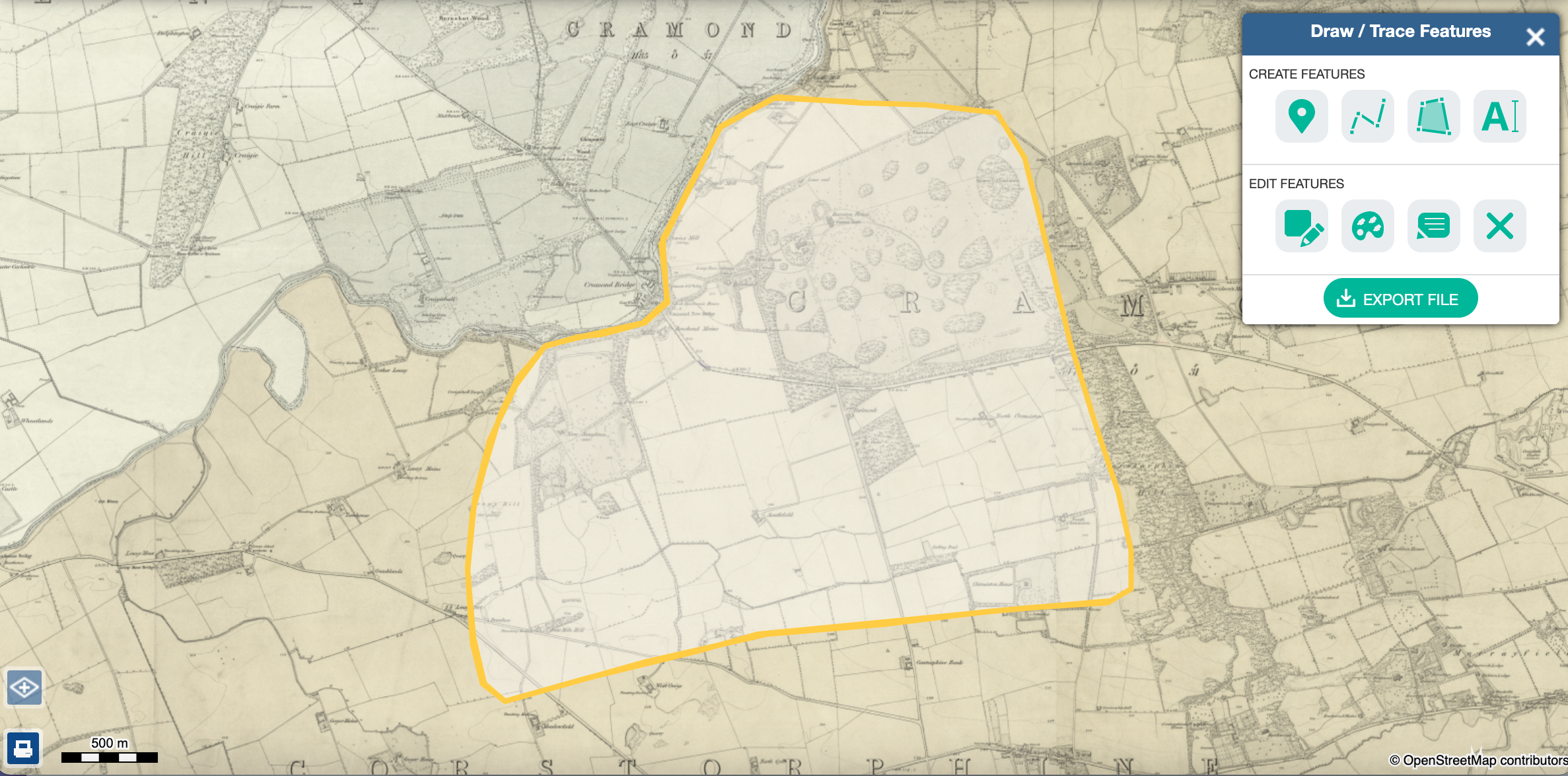
Here is the area in question:
I haven't been able to determine the exact historical extent of Cramond parish, but the 1794 map suggests that at least most of it is east of the River Almond (with a little bit west of the river to the north—too near the sea for Shaws, probably). The 'road to Stirling' in the 1794 map is the Glasgow road.
The route between Shaws and Queensferry, taken in chapter 5 and back again in chapter 29, is again not described in detail, but we do get the information that a northwest wind is blowing 'nearly in our faces'. Queensferry is on a bearing of approximately 280º from Cramond village, i.e. much closer to due west than northwest: more evidence that Shaws is south/inland from Cramond.
Now, because we're almost certainly east of the river, the characters would have to cross it to get to Queensferry, and the obvious place to do this is Cramond Bridge at NT1796475497. Queensferry is on a bearing of about 300º from the bridge, much closer to northwest, and the road runs pretty much directly there, so I think this is the route taken. The river bends upstream of the bridge to run west-east, but I don't think we can be very much further west than the bridge, as the route to Queensferry would then become too long (a bit more than three miles from the bridge) and circuitous (no longer consistently close to northwest, or at all if they crossed by a different bridge further west).
Finally, in chapter 30 David and Alan head towards Edinburgh from Shaws via 'the by-way over Corstorphine Hill'.
Putting all these clues together, the house of Shaws is:
This confines us to a fairly small area, and here is my very approximate drawing of it:
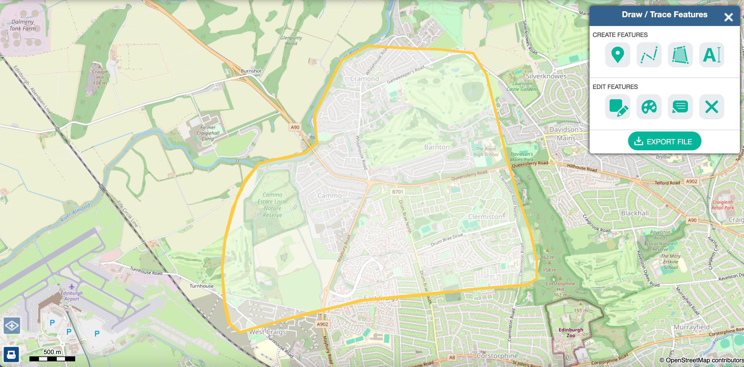
Most of this area now is modern housing estates, with a sizeable chunk being golf courses and then a smaller area covered by the Cammo Estate Local Nature Reserve, an eighteenth-century park (of which I may say more in a later post, as Cammo is possibly, among specific real houses, the most comparable to the house of Shaws).
One more point is worth mentioning. In the suburb of Clermiston, just west of Corstorphine Hill, is a cluster of streets named after characters and locations from Kidnapped. There's Essendean Place and Essendean Terrace, Hoseason Gardens, Ransome Gardens, Glenure Loan, Torrance Park and—my personal favourite—Alan Breck Gardens.* Imagine living on Alan Breck Gardens. I can't find any information about the rationale behind this—searching the street names just brings up property listings and so on—but this area is within my rough boundary for where Shaws could be: might it be that whoever was responsible for these names was acting on the belief that this is where the house stood??? Possibly, but I think the proximity to Corstorphine Hill (known as a significant place for the book; the statue is there, after all!) is probably more important.
*I discovered this early in my Kidnapped fannish life when, not knowing whether Essendean was a real place or not, I searched for it on Open Street Map and this was the only result.
Anyway: where is the house of Shaws?
The first thing we hear about the location of the house of Shaws is that it's 'not far from Cramond'. In chapter 2 David walks along the Glasgow road west of Edinburgh and enters Cramond parish; the description of his journey after this point is not very geographically detailed, but it is long enough to make clear that he travels some distance before reaching the house. When he does get there, the surroundings are described thus:
...a great bulk of building standing very bare upon a green in the bottom of the next valley. The country was pleasant round about, running in low hills, pleasantly watered and wooded, and the crops, to my eyes, wonderfully good... all set with hawthorn bushes full of flowers; the fields dotted with sheep; a fine flight of rooks in the sky; and every sign of a kind soil and climate...
Importantly, there's no mention of the sea; Cramond itself is right on the coast, so we're not very near the village. Again, in chapter 5 David wants to go to Queensferry because 'I wished for a nearer view of the sea and ships' (than he got from the hill above Edinburgh at the beginning of chapter 2, the only time the sea has been mentioned thus far).
Here is the area in question:
- In a rough map of Cramond parish from 1794
- On the Roy Military Survey map of the 1750s
- On the earliest large-scale Ordnance Survey map, from the 1850s
I haven't been able to determine the exact historical extent of Cramond parish, but the 1794 map suggests that at least most of it is east of the River Almond (with a little bit west of the river to the north—too near the sea for Shaws, probably). The 'road to Stirling' in the 1794 map is the Glasgow road.
The route between Shaws and Queensferry, taken in chapter 5 and back again in chapter 29, is again not described in detail, but we do get the information that a northwest wind is blowing 'nearly in our faces'. Queensferry is on a bearing of approximately 280º from Cramond village, i.e. much closer to due west than northwest: more evidence that Shaws is south/inland from Cramond.
Now, because we're almost certainly east of the river, the characters would have to cross it to get to Queensferry, and the obvious place to do this is Cramond Bridge at NT1796475497. Queensferry is on a bearing of about 300º from the bridge, much closer to northwest, and the road runs pretty much directly there, so I think this is the route taken. The river bends upstream of the bridge to run west-east, but I don't think we can be very much further west than the bridge, as the route to Queensferry would then become too long (a bit more than three miles from the bridge) and circuitous (no longer consistently close to northwest, or at all if they crossed by a different bridge further west).
Finally, in chapter 30 David and Alan head towards Edinburgh from Shaws via 'the by-way over Corstorphine Hill'.
Putting all these clues together, the house of Shaws is:
- Near Cramond
- Not very near the sea
- An appreciable distance away from the Glasgow road
- East of the River Almond
- Not very far west of Cramond Bridge
- West of Corstorphine Hill
This confines us to a fairly small area, and here is my very approximate drawing of it:
Most of this area now is modern housing estates, with a sizeable chunk being golf courses and then a smaller area covered by the Cammo Estate Local Nature Reserve, an eighteenth-century park (of which I may say more in a later post, as Cammo is possibly, among specific real houses, the most comparable to the house of Shaws).
One more point is worth mentioning. In the suburb of Clermiston, just west of Corstorphine Hill, is a cluster of streets named after characters and locations from Kidnapped. There's Essendean Place and Essendean Terrace, Hoseason Gardens, Ransome Gardens, Glenure Loan, Torrance Park and—my personal favourite—Alan Breck Gardens.* Imagine living on Alan Breck Gardens. I can't find any information about the rationale behind this—searching the street names just brings up property listings and so on—but this area is within my rough boundary for where Shaws could be: might it be that whoever was responsible for these names was acting on the belief that this is where the house stood??? Possibly, but I think the proximity to Corstorphine Hill (known as a significant place for the book; the statue is there, after all!) is probably more important.
*I discovered this early in my Kidnapped fannish life when, not knowing whether Essendean was a real place or not, I searched for it on Open Street Map and this was the only result.
no subject
Date: Apr. 13th, 2025 03:45 pm (UTC)no subject
Date: Apr. 13th, 2025 04:53 pm (UTC)no subject
Date: Apr. 14th, 2025 10:38 am (UTC)This is so interesting! I am quite convinced by your reasoning as you zoom in on that little area.
Imagine living on Alan Breck Gardens.
Haha, that would very cool.
no subject
Date: Apr. 14th, 2025 04:12 pm (UTC)no subject
Date: Apr. 25th, 2025 08:17 pm (UTC)What do you think about Illieston House as a model for Shaws?
I was going through this booklet
https://www.westlothian.gov.uk/media/53907/Country-Houses-Booklet-Summer-2022/pdf/Country_Houses.pdf
and my eye was immediately caught by the square stair-tower!
I like it a lot (I mean, not necessarily as inspiration for RLS, but in any case as something that fits my own mental image of the house very well.)
no subject
Date: Apr. 26th, 2025 08:36 am (UTC)What I'm struggling with is the statement that Shaws is five storeys high, excluding attics and the tower. That seems very tall for this sort of house!—the closest I can find in that booklet is Bridgecastle House, at four storeys for the main house and five for the tower. (Bridgecastle House also 'appeared to become a roofless ruin during most of the 18th century', ooh... But it's also even more in the wrong place, beyond Linlithgow...)
no subject
Date: Apr. 28th, 2025 11:35 am (UTC)Yeah, I admit that when I'm picturing Shaws, I don't picture it as "five storeys + attics" high, but only three or four. That's just so tall!
(Actually, I had a little poke around on the internet, just to find an example of what that would even look like, and could not find any examples of five-storeyed 18th-century houses in Scotland at all. Though no doubt there are some somewhere...)
no subject
Date: Apr. 28th, 2025 04:55 pm (UTC)Nor does it make much sense from a Doylist perspective: if RLS was deliberately exaggerating the size of Shaws beyond what was realistic, the obvious reason would be to emphasise how important the Balfours of Shaws are, and I don't think they are that important (they're landed gentry but not titled aristocracy; Alexander's disappearance was a local scandal but not apparently a national one).
...On the other hand, the houses in Edinburgh at this period were famous for being very tall, well beyond five storeys. I just checked my photo of the house in the Grassmarket from FotH, and it is exactly five storeys plus attics and a tower! And RLS was from Edinburgh, so he was probably more familiar with houses like that than with country houses; perhaps he was thinking 'like that, but in the country' and not appreciating how unlikely that was?
no subject
Date: Apr. 14th, 2025 06:31 pm (UTC)Cramond Bridge at NT1796475497
Is this some British way of giving a location?
no subject
Date: Apr. 14th, 2025 06:56 pm (UTC)Is this some British way of giving a location?
Yes, sorry, I could have explained that!—it's the National Grid system. (Basically, the two letters specify a 100x100km square, then the digits are east/west and north/south coordinates within that square). The NLS map viewer that I linked for the Ordnance Survey map shows the grid reference in the bottom right-hand corner as you mouse over the map, or you can look them up directly on this website.
no subject
Date: Apr. 14th, 2025 07:13 pm (UTC)Ah, I see! I've never seen a system like that which is given in just one number, instead of two (for east/west and north/south). But I suppose it's just a different way of organizing the information.
no subject
Date: Apr. 14th, 2025 07:22 pm (UTC)no subject
Date: Apr. 15th, 2025 10:11 am (UTC)This is great research, thank you for sharing.
no subject
Date: Apr. 16th, 2025 10:41 am (UTC)